A Hike to Lukomir Highland Village
Journey to a living museum
A Hike to Lukomir Highland Village
By Matias Gomez
Gornji Lukomir is Bosnia and Herzegovina’s highest and most remote village at 1,469 meters. It still clings to a rural life that is centuries old. Although Gornji Lukomir is accessible by car, hikers may want to visit this village through a spectacular and unforgettable walk from Umoljani, over Kobilica Mountain, and returning through Rakitnica Canyon.
Where to stay
There are several B&B’s in Umoljani and Lukomir. Umoljani has three restaurants –two of which offer private accommodation. In Lukomir there is a mountain lodge open for visitors. Online booking for accommodation can be done at www.sarajevo-travel.ba. See Bjelašnica Highlands listings section on page TKTK for more information.
Approach to Bjelašnica from Sarajevo
The M5 Sarajevo-to-Foča highway:
1) On the Sarajevo-to-Foča main road (which passes Sarajevo International Airport), turn right about seven kilometers from the airport (if traveling from Sarajevo). Follow signs to the Bjelašnica. Twelve kilometers after the turn, you get to the Police Training Center. Turn left and travel three kilometers further to get to the Hotel Maršal. This is the main ski center and hub of Bjelašnica Mountain.
Approach to trailhead
1) Via the main road, leave the Hotel Maršal on your left and drive in front of it in an easterly direction. After five kilometers, the road passes a saddle and starts descending to the valley floor.
2) Ignore a right turning to Lukavac and continue to a junction with three options. Take the middle road signed to Umoljani. A further 2.5 kilometers from this turn, take a right just before a bridge … again signed to Umoljani.
3) The road is paved for 3.3 kilometers to the village of Umoljani. In Umoljani take a left, followed by a smaller left, and then continue for around 100 meters to leave your car next to a cemetery (43°40.176N, 018°13.463E).
Mine Risk
There are mines close to other villages around four kilometers to the east of Umoljani. The risk is thus minor but make double sure you are starting in the right village and that you set off in the right direction (generally west).
The hike: Umoljani-Gornji Lukomir-Rakitnica Canyon
- Destination: Gornji Lukomir
- Mountain range: Bjelašnica
- Time for round trip: Six hours
- Physical difficulty: Medium
- Orientation difficulty: Medium
- Height gain: 450 meters
- Mine risk: Low
- Comment: A spectacular journey into Bosnia's past.
- GPS Ref Start (Umoljani): 43°40.176N, 018°13.463E
- GPS Ref Destination (Gornji Lukomir): 43°38.182N, 018°11.071E
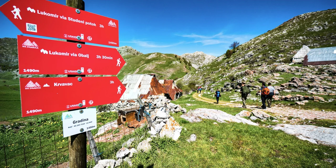
There are virtually no markings on this hike and hikers will need to use their orientation skills, especially for steps two and three (below). In other areas, trodden ground marks the correct path. The start of the hike (43°40.176N, 018°13.463E) is the continuation of the track upon which you have been driving.
1) Continue along the track up to Gradina – a collection of houses clearly visible on the ridge. In Gradina, turn left at a fork in the trail. Follow for only 100 meters or so and then turn right into a wide, open valley (Gornje Polje) and toward the stream. When you reach it, move upstream towards the head of the valley, which is surrounded by steep cliffs.
2) When you reach a spring just before the forest, a ramp emerges on your right. Turn right and move in a northerly direction, using this ramp to access the ridge above Gornje Polje. Once on the ridge, move in a southerly direction. Move uphill and follow the ridgeline over open and rough ground (no path markings).
3) Soon a valley emerges. It descends from the mountain in a westerly direction. Move down into this valley. Do not start descending the mountain along the bottom of the valley. Instead, find a faint path, which traverses its left side. The path increases in quality as you go along it. Ignore a left turn, which takes you up Obalj Mountain. The path continues to traverse across the side of the valley toward the Kovčeg shoulder of Obalj Mountain. Once you have turned the corner of this shoulder (43°39.144N, 018°11.071E), the path leads you to a descent into a valley. At the bottom of the valley, find a track that leads you south to the village of Gornji Lukomir (43°38.182N, 018°11.071E).
4) For the return journey, move to the south side of Gornji Lukomir, where there is a spectacular view of Rakitnica Canyon. Close to Lukomir's cemetery, find a path that begins to descend into the canyon while traversing it in an easterly direction.
5) Ignore minor turns that descend further into the canyon or rise up its flanks and maintain the traverse of the canyon. Occasional red-and-white paint markings appear on the path. Nonetheless, careful attention is required to follow the trail.
6) Around 1.5 hours after leaving Gornji Lukomir, you’ll cross the Studeni Stream and then traverse a mountain's shoulder. After this, there are a few moments of difficult trail searching before you find a clear path that goes above some mills below Sedrenik Spring and then descends to the road south of Umoljani. Follow the road back to your car.